

Preview
Creation Date
1953
Description
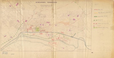
Published by the Tennessee State Planning Commission this 1953 planning map was compiled by the Sullivan County Tax Staff and from the Kingsport City Engineer's Map. Many area landmarks located in Kingsport and the surrounding area were added by hand at an indeterminate time post publication. These include area schools and businesses such as General Shale and Eastman Chemical Company. The hand written legend contains the color coding used to denote highways, schools, and new construction.
Physical copy resides in the Government Information, Law and Maps Department of East Tennessee State University’s Sherrod Library.
Dimensions
26"x51"
Rights
As a Tennessee state depository library per T. C. A. § 12-6-107, Sherrod Library is providing free and open access to this map as part of our Tennessee Documents Collection. This map is for research and educational purposes only. Sherrod Library makes no claim of copyright on this material.
Keywords
kingsport, tennessee, planning map, zoning map, rare map
