

Preview
Creation Date
9-2-1953
Description
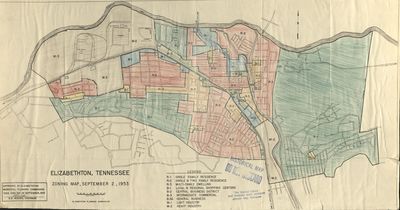
Zoning map of downtown Elizabethton, TN and the surrounding area. Legend includes notations of type of dwelling. Originally published in 1953 by the Elizabethton Planning Commission, the color portions were filled in by hand using colored pencil and correspond to the different zoning areas. It is unclear when the color was added. As you can see in the top left quarter of the map, this was before the creation of Sycamore Shoals State Park which was established in 1975 along the Watauga RIver and is located just northwest of downtown.
Physical copy resides in the Government Information, Law and Maps Department of East Tennessee State University’s Sherrod Library.
Dimensions
23"x13"
Rights
As a Tennessee state depository library per T. C. A. § 12-6-107, Sherrod Library is providing free and open access to this map as part of our Tennessee Documents Collection. This map is for research and educational purposes only. Sherrod Library makes no claim of copyright on this material.
Keywords
Elizabethton, Tennessee, Zoning, Zoning Map, Rare Map
