

Preview
Creation Date
6-19-2001
Description
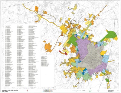
Produced by the Johnson City GIS Division on June 19, 2001, this map denotes the annexations of Johnson City and the surrounding area from 1960 to 2000. The map scale indicates a ratio of 1:24,000. In the text box on the left side, the ID, date, and annexation names are listed. As part of the legend, each 5 year annexation period is color coded. Physical copy resides with Johnson City, Geographic Information Systems Division.
Scale - 1"= 2000’
Dimensions
44" x 34"
Rights
This map is being provided with permission of Johnson City GIS Division. As a Tennessee state depository library per T. C. A. § 12-6-107, Sherrod Library is providing free and open access to this map as part of our Tennessee Documents Collection. This map is for research and educational purposes only. Responsibility for interpretation and application of this map lies with the user. Sherrod Library makes no claim of copyright on this material. For additional use or rights of this map, please contact the GIS Division of Johnson City.
Keywords
Johnson City, Tennessee, GIS, Annexations, City Map, Rare Map
