

Preview
Creation Date
1942
Description
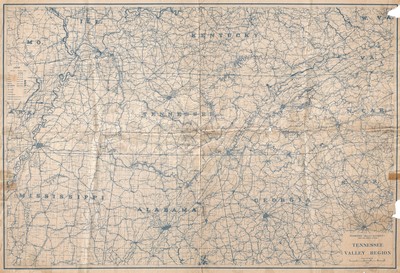
General map of the Tennessee Valley Region published in 1942 by the Tennessee Valley Authority, Maps and Surveys Division. The legend denotes town populations, highways, and National Parks and Reservations. Additional information such as waterways, railroads, and communities are labeled on the map itself.
Physical copy resides in the Government Information, Law and Maps Department of East Tennessee State University’s Sherrod Library.
Scale - 1"= 10 miles
Dimensions
34" x 46"
Rights
As a Federal Depository per Title 44 U.S.C., Sherrod Library is providing free and open access to this map as part of our Federal Depository Collection. This map is for research and educational purposes only. Sherrod Library makes no claim of copyright on this material. It is the user's obligation to determine and satisfy copyright or other use restrictions when publishing or otherwise distributing materials.
Keywords
Tennessee Valley, Tennessee Valley Authority, Regional Map, Rare Map
