

Preview
Creation Date
1876
Description
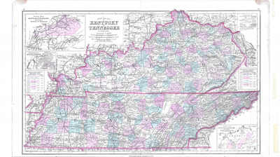
Scale 1 inch = 15 nautical miles (18 English statute miles). Includes mountain ranges, rivers, creeks, railroads, counties, cities, and towns. State borders are traced in color, counties are lightly tinted and relief is show by hachures. Insets include hypsometric map illustrating elevation relative to sea level, outline map of railroad systems, population density map and tables summarizing population growth over time. Printed below the title, "by Frank A. Gray." Printed below map frame, "Philadelphia: O. W. Gray and Son." According to the collector's notes, this map was copyrighted in 1876.
Dimensions
72 x 44 cm
Rights
The Archives of Appalachia at East Tennessee State University provides access to these materials for the purposes of research and education and is not aware of any U.S. copyright protection or any other restrictions for this item. Any commercial uses of the materials or any uses that exceed the limits of fair use and other relevant statutory exceptions may require the permission of any copyright holder(s). It is the user's obligation to determine and satisfy copyright or other use restrictions when publishing or otherwise distributing materials. Preferred citation: [identification of item], Archives of Appalachia, East Tennessee State University.
Keywords
Archives of Appalachia, rare map, Kentucky, Tennessee
