

Preview
Creation Date
1875
Description
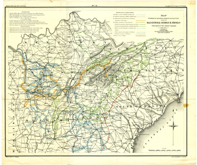
Scale 1 inch = 40 miles. Map No. 16 out of twenty-two maps published in History of the Army of the Cumberland, by Edward Ruger and Thomas B. Van Horne (Cincinnati : Robert Clarke & Co., 1875). These maps collectively illustrate the various battles in and around Tennessee by the Army of the Cumberland. Map No. 16 details troop movements in and around east Tennessee. Compiled by Edward Ruger, who worked for the Topographical Engineers and had access to the War Department maps and plans. Printed by the Krebs Lithographing Co., Cincinnati.
Dimensions
46 x 38 cm
Rights
The Archives of Appalachia at East Tennessee State University provides access to these materials for the purposes of research and education and is not aware of any U.S. copyright protection or any other restrictions for this item. Any commercial uses of the materials or any uses that exceed the limits of fair use and other relevant statutory exceptions may require the permission of any copyright holder(s). It is the user's obligation to determine and satisfy copyright or other use restrictions when publishing or otherwise distributing materials. Preferred citation: [identification of item], Archives of Appalachia, East Tennessee State University.
Keywords
Archives of Appalachia, rare map, Kentucky, Virginia, Tennessee, North Carolina, South Carolina, Georgia, Alabama, Mississippi
