

Preview
Creation Date
1838
Description
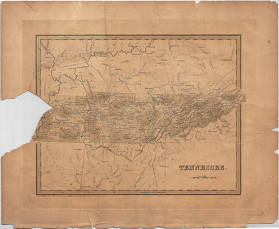
This map depicts Tennessee in the 1830s with counties named and delineated. Topographical features are shown with various land routes, water routes, mountains, cities, towns, forts, post offices, and other details identified. Engraved by G.W. Boynton. Published in T.G. Bradford, An Illustrated Atlas, Geographical, Statistical and Historical of the United States and Adjacent Countries (Boston: Weeks, Jordan and Co., 1838). Scale 1 in = 30 miles.
Dimensions
49 x 41 cm
Rights
The Archives of Appalachia at East Tennessee State University provides access to these materials for the purposes of research and education and is not aware of any U.S. copyright protection or any other restrictions for this item. Any commercial uses of the materials or any uses that exceed the limits of fair use and other relevant statutory exceptions may require the permission of any copyright holder(s). It is the user's obligation to determine and satisfy copyright or other use restrictions when publishing or otherwise distributing materials. Preferred citation: [identification of item], Archives of Appalachia, East Tennessee State University.
Keywords
Archives of Appalachia, rare map, Tennessee
