

Preview
Creation Date
1968
Description
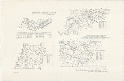
Includes four hand drawn maps: a complete map of Tennessee, indicating dates and locations for 26 treaties with Native Americans from the 18th and 19th centuries, traced from W.R. Garrett and A.V. Goodpasture, History of Tennessee, Its People and Its Institutions (Nashville, 1900), pages 128-129; and a tripartite map of east, middle, and west Tennessee (traced from 1968 issue by AAA) indicating state lines, county lines, and locations of county seats. Drawn May 1968 by Katherine W. Ewing, Nashville. Copyright Katherine W. Ewing, 1973.
Dimensions
90 x 59 cm
Rights
The Archives of Appalachia at East Tennessee State University provides access to these materials for the purposes of research and education and is not aware of any U.S. copyright protection or any other restrictions for this item. Any commercial uses of the materials or any uses that exceed the limits of fair use and other relevant statutory exceptions may require the permission of any copyright holder(s). It is the user's obligation to determine and satisfy copyright or other use restrictions when publishing or otherwise distributing materials. Preferred citation: [identification of item], Archives of Appalachia, East Tennessee State University.
Keywords
Archives of Appalachia, rare map, Tennessee
