

Preview
Creation Date
1968
Description
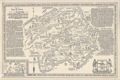
Includes county history and military history, along with two inset maps: one of the town of Salem as it existed in 1802 and one of Augusta County as it existed in 1738. Compiled from old maps, historical records, and traditions by J.R. Hildebrand. The Roanoke Historical Society, 1968. No scale provided.
Dimensions
79 x 53 cm
Rights
The Archives of Appalachia at East Tennessee State University provides access to these materials for the purposes of research and education and is not aware of any U.S. copyright protection or any other restrictions for this item. Any commercial uses of the materials or any uses that exceed the limits of fair use and other relevant statutory exceptions may require the permission of any copyright holder(s). It is the user's obligation to determine and satisfy copyright or other use restrictions when publishing or otherwise distributing materials. Preferred citation: [identification of item], Archives of Appalachia, East Tennessee State University.
Keywords
Archives of Appalachia, rare map, Virginia, Roanoke County
