

Preview
Creation Date
3-28-2006
Description
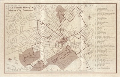
Created 3/28/2006 by Johnson City GIS, this map provides a tour of historic places in Johnson City, Tennessee. Historic sites are listed on the right edge and are denoted by numbers which correspond to places on the map.Road names are listed on the map itself. Physical copy resides with Johnson City, Geographic Information Systems Division.
Scale - 1" = 0.257260 miles
Dimensions
11" x 17"
Rights
This map is being provided with permission of Johnson City GIS Division. As a Tennessee state depository library per T. C. A. § 12-6-107, Sherrod Library is providing free and open access to this map as part of our Tennessee Documents Collection. This map is for research and educational purposes only. Responsibility for interpretation and application of this map lies with the user. Sherrod Library makes no claim of copyright on this material. For additional use or rights of this map, please contact the GIS Division of Johnson City.
Keywords
Johnson City, Johnson City GIS, historic places, historic tour, city map, rare maps
