

Preview
Creation Date
1993
Description
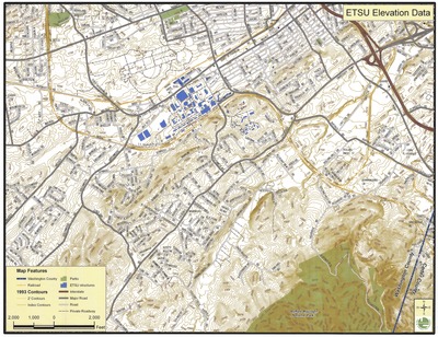
Map of ETSU Elevation Data created by Johnson City GIS using 1993 contours. Map features listed on the bottom left corner includes major roads, ETSU structures, parks, and railroads. Physical copy resides with Johnson City, Geographic Information Systems Division.
Scale: 5" = 2000 ft.
Dimensions
27" x 21"
Rights
This map is being provided with permission of Johnson City GIS Division. As a Tennessee state depository library per T. C. A. § 12-6-107, Sherrod Library is providing free and open access to this map as part of our Tennessee Documents Collection. This map is for research and educational purposes only. Responsibility for interpretation and application of this map lies with the user. Sherrod Library makes no claim of copyright on this material. For additional use or rights of this map, please contact the GIS Division of Johnson City.
Keywords
Johnson City GIS, ETSU, east tennessee state university, elevation, rare maps
