

Preview
Creation Date
1983
Description
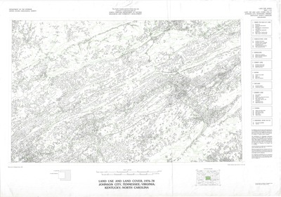
Published in 1983 by the U.S. Geological Survey, this map denotes land use and land cover in the northeast Tennesee/Johnson City area for the years 1975-83. Base map from U.S. Geologic Survey, 1966. The legend along the right edge denotes different types of land use and coverage using a numeric code. Additional details on how the map was compiled can by found on the lower right corner. The North Carolina portion of this map was prepared in cooperation with the North Carolina Department of Natural Resources and Community Development.
Physical copy resides in the Government Information, Law and Maps Department of East Tennessee State University’s Sherrod Library.
Scale - 1: 250,000.
Dimensions
34.5" x 24"
Rights
As a Federal Depository per Title 44 U.S.C., Sherrod Library is providing free and open access to this map as part of our Federal Depository Collection. This map is for research and educational purposes only. Sherrod Library makes no claim of copyright on this material. It is the user's obligation to determine and satisfy copyright or other use restrictions when publishing or otherwise distributing materials.
Keywords
land use, northeast tennesee, natural resources, map, southern appalachia
