

Preview
Creation Date
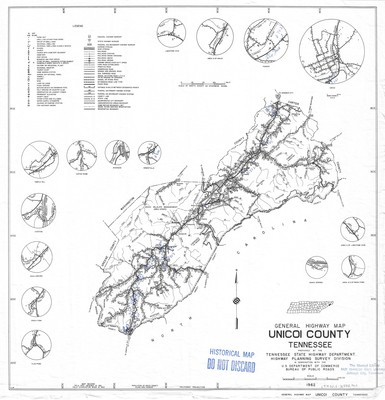
1962
Description
General highway map of Unicoi County, Tennessee prepared by the Tennessee State Highway Department, Highway Planning Survey Division in cooperation with the U.S. Department of Commerce Bureau of Public Roads. Field data obtained in 1961. Field Examination made in 1962. Legend denotes multiple categories including dwellings and businesses as well as county infrastructure. Several insets of specific communities and areas of interest are included. Population statistics can be found along the bottom border. Lines of longitude and latitude are listed along the outside border. Additional details were added by hand in blue ink at an indeterminate time post publication.
Physical copy resides in the Government Information, Law and Maps Department of East Tennessee State University’s Sherrod Library.
Scale for general map - 1/2" = 1 mile
Scale for insets except as otherwise shown - 1/2" = 1/4 mile
Dimensions
24" x 18"
Rights
As a Tennessee state depository library per T. C. A. § 12-6-107, Sherrod Library is providing free and open access to this map as part of our Tennessee Documents Collection. This map is for research and educational purposes only. Sherrod Library makes no claim of copyright on this material. It is the user's obligation to determine and satisfy copyright or other use restrictions when publishing or otherwise distributing materials.
Keywords
Tennessee, highway map, historical map, rare map, unicoi, erwin
