

Preview
Creation Date
1958
Description
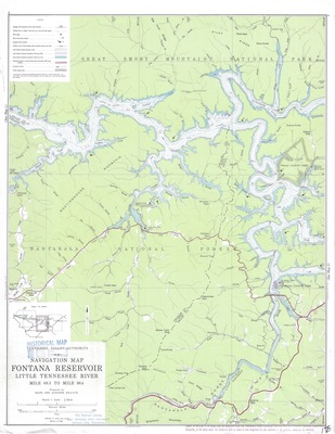
Navigation Map of Fontana Reservoir published in 1958 by the Tennessee Valley Authority, Maps and Surveys Branch. Sheet 1 of a series of 3 maps covering Fontana Reservoir. This sheet covers mile 68.5 to mile 86.4. The index for the 3 map series can be found in the lower left quadrant. The legend denotes several information items pertaining to lake levels, direction of flow, roads, bridges, and other points of interest.
Physical copy resides in the Government Information, Law and Maps Department of East Tennessee State University’s Sherrod Library.
Scale: 1" = .5 mile. Datum is mean sea level.
Dimensions
17.5" x 22"
Rights
As a Federal Depository per Title 44 U.S.C., Sherrod Library is providing free and open access to this map as part of our Federal Depository Collection. This map is for research and educational purposes only. Sherrod Library makes no claim of copyright on this material. It is the user's obligation to determine and satisfy copyright or other use restrictions when publishing or otherwise distributing materials.
Keywords
Navigation Map, Reservoir Map, TVA, Fontana Reservoir, Little Tennessee River, Rare Map
