

Preview
Creation Date
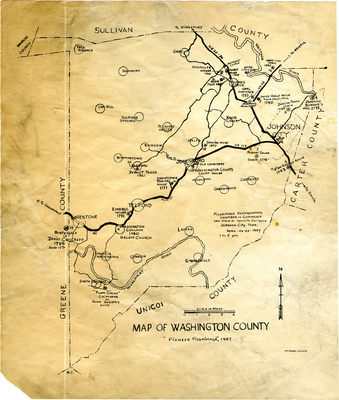
1957
Description
Hand drawn map created by Milburn Divine, identifying circa 20 historic structures from the 18th and 19th centuries. Includes Kitzmiller House, Pearce House, Been Cabin Site, Peter Range House, Jeremiah Dungan Mill, Darling Jones Cabin, Tipton Haynes House, Robert Young Cabin, Christopher Taylor House, DeVault Tavern, Embree House, Washington College, and others. Scale 1 in = 2.5 miles.
Dimensions
30 x 26 cm
Rights
The Archives of Appalachia at East Tennessee State University provides access to these materials for the purposes of research and education and is not aware of any U.S. copyright protection or any other restrictions for this item. Any commercial uses of the materials or any uses that exceed the limits of fair use and other relevant statutory exceptions may require the permission of any copyright holder(s). It is the user's obligation to determine and satisfy copyright or other use restrictions when publishing or otherwise distributing materials. Preferred citation: [identification of item], Archives of Appalachia, East Tennessee State University.
Keywords
Archives of Appalachia, rare map, Tennessee, Washington County, Johnson City
