

Preview
Creation Date
9-27-1983
Description
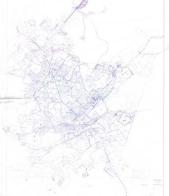
Zoning map for the city of Johnson City and the outlying areas. Original map was drawn January 11, 1972 and was originally adopted by the city April 20, 1972. This revised map is a duplicate of the original and was produced September 27, 1983. This was likely when the hand drawn lines were added to update the zoning districts. Most main streets are also labeled with arterial streets notated by dotted lines. While not included in the legend, it is likely that R stands for residential and I for industrial.
East Tennessee State University can be found in zone R-6 located next to Greenwood Drive. The left portion of the map has been cut as you can see by the title Johnson City partially missing. No accompanying maps are found in the collection.
Physical copy resides in the Government Information, Law and Maps Department of East Tennessee State University’s Sherrod Library.
Dimensions
36" x 42"
Rights
As a Tennessee state depository library per T. C. A. § 12-6-107, Sherrod Library is providing free and open access to this map as part of our Tennessee Documents Collection. This map is for research and educational purposes only. Sherrod Library makes no claim of copyright on this material.
Keywords
Johnson City, Zoning, Tennessee, Maps, Rare Map
