

Preview
Creation Date
10-1959
Description
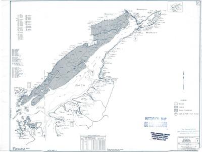
Map of Watauga Reservoir Properties published in October 1959 by the Tennessee Valley Authority, Division of Reservoir Properties. Compiled from Maps and Surveys "C" stage reservation maps.The Watauga Reservoir Property Map series is divided into 3 sheets, this is sheet 2 of 3. The legend denotes retained, surplus, or transferred land. The box on the lower half includes information such as approximate acreage of tracts and sale or transfer designation. Lake front property owners (as of 1959) are listed on the top left quadrant as well included on the map itself.
Physical copy resides in the Government Information, Law and Maps Department of East Tennessee State University’s Sherrod Library.
Scale: 1" = 2000'
Dimensions
14" x 19"
Rights
As a Federal Depository per Title 44 U.S.C., Sherrod Library is providing free and open access to this map as part of our Federal Depository Collection. This map is for research and educational purposes only. Sherrod Library makes no claim of copyright on this material. It is the user's obligation to determine and satisfy copyright or other use restrictions when publishing or otherwise distributing materials.
Keywords
Property Map, Watauga Lake, Historical Map, Rare Map, TVA
