

Preview
Creation Date
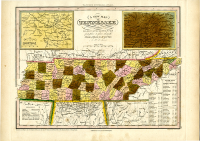
1841
Description
Scale 1 inch = 30 miles. Drawn by H.S. Tanner and engraved by J. & W. W. Warr in 1841. Hand-colored map of Tennessee detailing the state's transportation infrastructure. Roads (along with distances), stage routes, and steamboat routes are shown. A legend indicates canals, railroads, towns, leading roads, and the state capital. Insets of Knoxville and Nashville appear in the upper corners.
Dimensions
44 x 40 cm
Rights
The Archives of Appalachia at East Tennessee State University provides access to these materials for the purposes of research and education and is not aware of any U.S. copyright protection or any other restrictions for this item. Any commercial uses of the materials or any uses that exceed the limits of fair use and other relevant statutory exceptions may require the permission of any copyright holder(s). It is the user's obligation to determine and satisfy copyright or other use restrictions when publishing or otherwise distributing materials. Preferred citation: [identification of item], Archives of Appalachia, East Tennessee State University.
Keywords
Archives of Appalachia, rare map, Tennessee
