

Preview
Creation Date
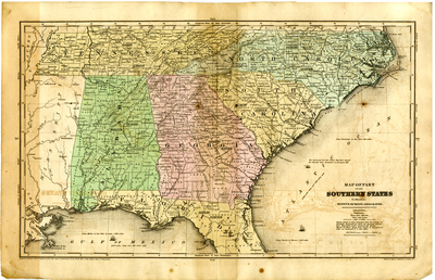
1845
Description
No scale provided. Drawn and engraved by the firm of Sherman & Smith of New York and bears an 1844 copyright in favor of D. F. Robinson. The map portrays Tennessee, North Carolina, South Carolina, Georgia, Alabama, and the northern part of Florida. Railroads, cities and towns, and canals are shown. The sites of significant battles are noted. Rivers and other topographical features are identifed. Relief is shown by hachures. The population from the 1840 census and area in square miles for each state are reported on the face of the map.
Dimensions
48 x 31 cm
Rights
The Archives of Appalachia at East Tennessee State University provides access to these materials for the purposes of research and education and is not aware of any U.S. copyright protection or any other restrictions for this item. Any commercial uses of the materials or any uses that exceed the limits of fair use and other relevant statutory exceptions may require the permission of any copyright holder(s). It is the user's obligation to determine and satisfy copyright or other use restrictions when publishing or otherwise distributing materials. Preferred citation: [identification of item], Archives of Appalachia, East Tennessee State University.
Keywords
Archives of Appalachia, rare map, Tennessee, North Carolina, South Carolina, Georgia, Alabama, Mississippi, Florida
