

Preview
Creation Date
1817
Description
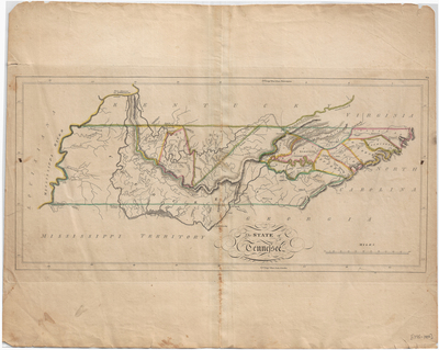
This map is revised from the earlier map of "The State of Tennessee" published in Carey's General Atlas in 1814, 1815, and 1816. New towns shown with various connecting roads are Franklin, Columbia, Pulaski, Vernon, Jefferson, McMinnville, Madison, Washington, Springfield, and Hendersonville in middle Tennessee. Sevierville, Newport, Warm Spring, and Blountsville are in east Tennessee. It was published in Mathew Carey, Carey's General Atlas (Philadelphia: Mathew Carey and Son, 1817). Scale 1 in = 27 miles.
Dimensions
55 x 43 cm
Rights
The Archives of Appalachia at East Tennessee State University provides access to these materials for the purposes of research and education and is not aware of any U.S. copyright protection or any other restrictions for this item. Any commercial uses of the materials or any uses that exceed the limits of fair use and other relevant statutory exceptions may require the permission of any copyright holder(s). It is the user's obligation to determine and satisfy copyright or other use restrictions when publishing or otherwise distributing materials. Preferred citation: [identification of item], Archives of Appalachia, East Tennessee State University.
Keywords
Archives of Appalachia, rare map, Tennessee
