

Preview
Creation Date
1973
Description
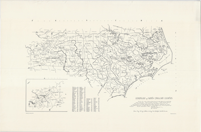
Tracing of a modern highway map showing principal watercourses, county seats, present county lines. County derivations taken from "Chart Showing Origin of North Carolina Counties" by D.L. Corbitt of the NC Historical Commission and L. Polk Denmark of the State Highway and Public Works Commission. Published 1940 by the NC Historical Commissions with note: "Date shown is that of Assembly which authorized formation of county." Drawn May 1968 by Katherine W. Ewing, Nashville, Tennessee. Copyright Katherine W. Ewing, 1973. No scale provided.
Dimensions
90 x 59 cm
Rights
The Archives of Appalachia at East Tennessee State University provides access to these materials for the purposes of research and education and is not aware of any U.S. copyright protection or any other restrictions for this item. Any commercial uses of the materials or any uses that exceed the limits of fair use and other relevant statutory exceptions may require the permission of any copyright holder(s). It is the user's obligation to determine and satisfy copyright or other use restrictions when publishing or otherwise distributing materials. Preferred citation: [identification of item], Archives of Appalachia, East Tennessee State University.
Keywords
Archives of Appalachia, rare map, North Carolina
