

Preview
Creation Date
1855
Description
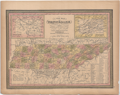
Lithograph, hand-colored by county. Indicates canals, rail roads, state capital, county towns, and leading roads. Includes steam boat routes to Pittsburg and New Orleans, and two insets featuring environs of Nashville and environs of Knoxville. Entered according to act of Congress in the year 1850. Published by Thomas, Cowperthwait, and Co. Scale 1 in = 30 miles.
Dimensions
43 x 35 cm
Rights
The Archives of Appalachia at East Tennessee State University provides access to these materials for the purposes of research and education and is not aware of any U.S. copyright protection or any other restrictions for this item. Any commercial uses of the materials or any uses that exceed the limits of fair use and other relevant statutory exceptions may require the permission of any copyright holder(s). It is the user's obligation to determine and satisfy copyright or other use restrictions when publishing or otherwise distributing materials. Preferred citation: [identification of item], Archives of Appalachia, East Tennessee State University.
Keywords
Archives of Appalachia, rare map, Tennessee
