

Preview
Creation Date
1985
Description
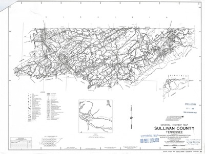
General highway map of Sullivan County, Tennessee prepared by the Tennessee Department of Transportation, Bureau of Planning and Development-Planning Division in cooperation with the U.S. Department of Transportation, Federal Highway Administration. Field data obtained in 1978. Field Examination made in 1985. The road names shown on this map were approved by the Sullivan County Commission in 1985.
Legend denotes multiple categories including dwellings and businesses as well as county infrastructure. An inset of Friendship Road can be found on the lower portion. Lines of longitude and latitude are listed along the outside border.
Physical copy resides in the Government Information, Law and Maps Department of East Tennessee State University’s Sherrod Library.
Scale for general map - 1/2" = 1 mile
Dimensions
24" x 18"
Rights
As a Tennessee state depository library per T. C. A. § 12-6-107, Sherrod Library is providing free and open access to this map as part of our Tennessee Documents Collection. This map is for research and educational purposes only. Sherrod Library makes no claim of copyright on this material. It is the user's obligation to determine and satisfy copyright or other use restrictions when publishing or otherwise distributing materials.
Keywords
Tennessee, highway map, historical map, rare map, sullivan county
