

Preview
Creation Date
1823
Description
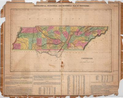
This map is much the same as "Tennessee" published in Carey and Lea's American Atlas in 1822. Like that map, it includes border text with information about the state below the map and on a separate appendix sheet. It has 52 counties, each colored separately. Many rivers are given, as are mountain ranges. Southeastern Tennessee has "Cherokee Lands" and Ross's. Roads through central and eastern parts of the state are drawn, with Nashville and Knoxville being crossroads of travel. No area beyond the state is mapped, except for lands in Alabama which fall within the Tennessee River. Franklin County is spelled "Eranklin" with Maury spelled "Murray." Unlike that map, it shows "Brainerd one of the Missionary Stations" in southeastern Tennessee. Drawn by F. Lucas Jr. Published in H.C. Carey and I. Lea, A Complete Historical, Chronological, and Geographical American Atlas (Philadelphia: H.C. Carey and I. Lea, 1823). Scale 1 in = 27 miles.
Dimensions
45 x 56 cm
Rights
The Archives of Appalachia at East Tennessee State University provides access to these materials for the purposes of research and education and is not aware of any U.S. copyright protection or any other restrictions for this item. Any commercial uses of the materials or any uses that exceed the limits of fair use and other relevant statutory exceptions may require the permission of any copyright holder(s). It is the user's obligation to determine and satisfy copyright or other use restrictions when publishing or otherwise distributing materials. Preferred citation: [identification of item], Archives of Appalachia, East Tennessee State University.
Keywords
Archives of Appalachia, rare map, Tennessee
