

Preview
Creation Date
1966
Description
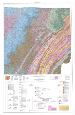
Geologic map of Tennessee published in 1966 by the Tennessee Department of Conservation, Division of Geology. William D. Hardeman supervised and directed this geologic mapping and the compilation, preparation, and editing of this map. The source material for the map includes all recent (as of 1966) detailed published geologic maps and much recent unpublished geologic mapping that was begun and completed by the Division of Geology for the specific purpose of making this map of uniform accuracy through the state.
The scale is 1:250,000 with the lower half including a detailed explanation including symbols/colors for rock types, mountain formations, and other geologic features. The sources of geologic information is also included.
Physical copy resides in the Government Information, Law and Maps Department of East Tennessee State University’s Sherrod Library.
Dimensions
32" x 48"
Rights
As a Tennessee state depository library per T. C. A. § 12-6-107, Sherrod Library is providing free and open access to this map as part of our Tennessee Documents Collection. This map is for research and educational purposes only. Sherrod Library makes no claim of copyright on this material.
Keywords
geology, geologic map, Tennessee Map, East Tennessee
