
Preview
Description
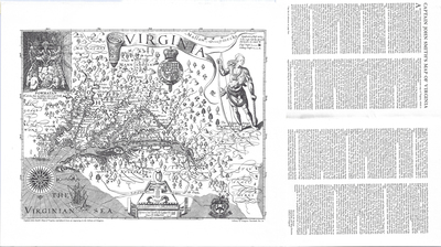
Scale 1 inch = 6 leagues. Library of Congress facsimile No. 1a, which is based on the sixth out of ten issues (known as "states"). The original map was published in 1612, and the revisions comprising the sixth state are from 1624. The map includes ca. 200 names including Native American tribes, and is considered the first authoritative map of Virginia.
Dimensions
48 x 41 cm
Rights
The Archives of Appalachia at East Tennessee State University provides access to these materials for the purposes of research and education and is not aware of any U.S. copyright protection or any other restrictions for this item. Any commercial uses of the materials or any uses that exceed the limits of fair use and other relevant statutory exceptions may require the permission of any copyright holder(s). It is the user's obligation to determine and satisfy copyright or other use restrictions when publishing or otherwise distributing materials. Preferred citation: [identification of item], Archives of Appalachia, East Tennessee State University.
Keywords
Archives of Appalachia, rare map, Virginia