

Preview
Description
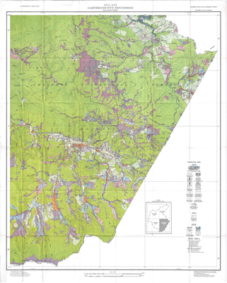
Tennessee Agricultural Experiment Station, Tennessee Valley Authority. US Department of Agriculture. Soils surveyed 1940-1942. Map compilation by Cartographic Section, Division of Soil Survey, BPISAE, from TVA planimetric maps, TVA controlled mosaics, and aerial photographs. H.W. Whitlock, Engineer in Charge. Polyconic projection. 1927 North American datum. Scale 1 in = 2000 ft.
Dimensions
78x 99 cm
Rights
The Archives of Appalachia at East Tennessee State University provides access to these materials for the purposes of research and education and is not aware of any U.S. copyright protection or any other restrictions for this item. Any commercial uses of the materials or any uses that exceed the limits of fair use and other relevant statutory exceptions may require the permission of any copyright holder(s). It is the user's obligation to determine and satisfy copyright or other use restrictions when publishing or otherwise distributing materials. Preferred citation: [identification of item], Archives of Appalachia, East Tennessee State University.
Keywords
Archives of Appalachia, rare map, Tennessee, Carter County
