
Preview
Creation Date
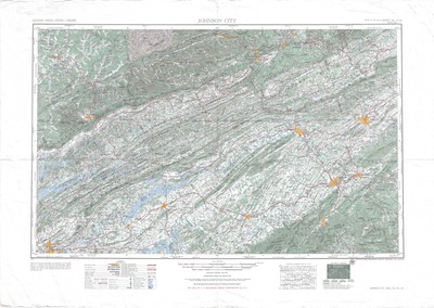
1955
Description
Large topographical map of the northeast Tennessee region around Johnson City published in 1955. Prepared by the Army Map Service, Corps of Engineers, U.S. Army, Washington D.C. Compiled in 1951 from United States Quadrangles, U.S. Geological Survey, and county highway maps. Planimetric detail partially revised by photo-planimetric methods. Control by USC & GS, TVA, and CE. Roads, railroad and aeronautical data verified by state authorities, 1954.
Legend denotes populated places, types of roads, and railroads. Topography, names of roads, communities, and waterways can be found on the map itself.
Physical copy resides in the Government Information, Law and Maps Department of East Tennessee State University’s Sherrod Library.
Scale - 1: 250,000
Dimensions
34" x 24"
Rights
As a Federal Depository per Title 44 U.S.C., Sherrod Library is providing free and open access to this map as part of our Federal Depository Collection. This map is for research and educational purposes only. Sherrod Library makes no claim of copyright on this material. It is the user's obligation to determine and satisfy copyright or other use restrictions when publishing or otherwise distributing materials.
Keywords
Johnson City Map, topographic map, USGS, map