
Title
Historical Map of Hawkins County Tennessee 1771 - 1971 by Louis T. Ketron (file mapcoll_002_11)
Preview
Creation Date
1971
Description
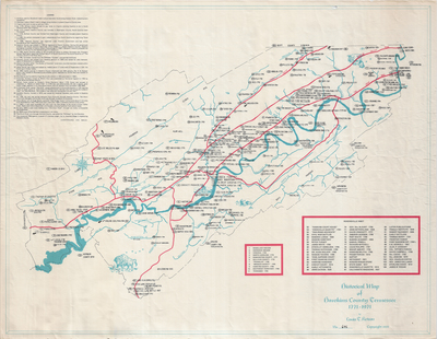
No scale provided. Drawn by Louis T. Ketron in 1971. Map of Hawkins County (Tenn.) marking historically significant spots from 1771 to 1971. A legend in the front upper left corner (continues on back) lists over 400 events important to the history of Hawkins County, including the founding of Rogersville, a Civil War battle in Rogersville, the organization of the first Circuit Court, and the establishment of post offices.
Dimensions
73 x 58 cm
Rights
The Archives of Appalachia at East Tennessee State University provides access to these materials for the purposes of research and education and is not aware of any U.S. copyright protection or any other restrictions for this item. Any commercial uses of the materials or any uses that exceed the limits of fair use and other relevant statutory exceptions may require the permission of any copyright holder(s). It is the user's obligation to determine and satisfy copyright or other use restrictions when publishing or otherwise distributing materials. Preferred citation: [identification of item], Archives of Appalachia, East Tennessee State University.
Keywords
Archives of Appalachia, rare map, Tennessee, Hawkins County