
Preview
Creation Date
1973
Description
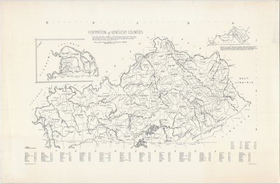
Large map traced from an official 1964 Road Map of the Commonwealth of Kentucky distributed by the Travel Division, Department of Public Information at Frankfort. County origins taken from Julia Spencer Ardery's Kentucky Court and Other Records (1932, Lexington, Ky), pp. 7-9. Includes an inset map that is an approximation of boundary lines taken from a map in Keinemann and Brumbaugh's "First Census of Kentucky, 1790 (1940, Washington, D.C.), entitled "Counties of Kentucky 1792 in respect to Modern Counties." Drawn June 1968 by Katherine W. Ewing, Nashville, Tennessee. Copyright Katherine W. Ewing, 1973. No scale provided.
Dimensions
90 x 59 cm
Rights
The Archives of Appalachia at East Tennessee State University provides access to these materials for the purposes of research and education and is not aware of any U.S. copyright protection or any other restrictions for this item. Any commercial uses of the materials or any uses that exceed the limits of fair use and other relevant statutory exceptions may require the permission of any copyright holder(s). It is the user's obligation to determine and satisfy copyright or other use restrictions when publishing or otherwise distributing materials. Preferred citation: [identification of item], Archives of Appalachia, East Tennessee State University.
Keywords
Archives of Appalachia, rare map, Kentucky